The earthquakes in Japan have been a wake up call for me and my East Bay neighbors. I often drive the length of the Hayward Earthquake fault – between Fremont and Berkeley. Along the entire route I am within a half mile of the fault. This fault had produced an earthquake on the range of more than 7 magnitude every 140 years ( last time in 1868) And according to geologic records there have been 5 major earthquake, regular as clockwork, every 140 years! Gulp... its time! Since the last large quake the East bay cities have built up with homes, schools, hospitals, the BART transit system - vitually on top of the fault. (Our home is within half a mile.) It is not a question of “if” it is a matter of “when”…and earthquake prediction is not a developed science.

Earthquakes are due to the gradual build up of tension and distortion in the earths crust – caused by the gradual westward drifting of the North American contental mass over the Pacific sea floor crust. When the tension builds to a critical level it snaps all at once (like slowly bending a stick until it suddenly breaks). There is a continual slow creep of a few mm. a year along the surface of our fault, but deep in the earth it is locked in place.
Our California faults are of the horizontal slip variety – It is anticipated that the Hayward fault will produce a horizontal shift of 6-8 ft. BART lines and roads cross the fault in many places -imagine the disruption! Earthquake faults also are known to exist on the ocean floor – but horizontal slip faults don’t generally produce major tsumanis…
An earthquake with a 2 on the Richter scale has 10 times more movement than a one. A "3" earthquake is 10 x 10 or 100 X stronger than a 1. A "4" is 10 x 10 x 10 or a thousand times greater than a "1".

Since the fault runs through heavily populated areas, more than 5 million people will be affected directly. Water may be cut off to 2.4 million people living in California's San Francisco Bay Area. The number of lives lost would depend on the time of day, the severity of the quake, and its epicenter. From what we learned in Japan imagine the benefits of having an emergency backup plan in place!
Most people choose not to buy earthquake insurance - because of the huge deductable (at least 15%), and the high cost of annual payments. Many people instead are spending money on retro- fittting their homes... making certain that the house is bolted securely to the foundation, adding additional internal or roof supports if needed. If a house is burned as a result of the earthquake, it would be covered with fire insurance.

Best preparation: Know what to expect, and plan ahead!
1. Many communities have trained community response volunteers ready to assist in search and rescue, fire control, medical aid when needed. My community has a CERT program in place. They welcome new volunteers who seek training:
http://www.citizencorps.gov/cert/start-3-1g.shtm
2. FEMA has an excellent web site on what to do before, during and after an earthquake – good reference:
http://www.fema.gov/hazard/earthquake/3. Learn about the potential for shaking in your area based on your subsoil type: ( you must use the controls to find your street and home location)
http://gis.abag.ca.gov/website/liquefactionsusceptibility/
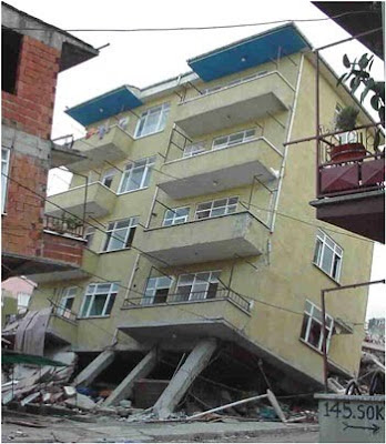
Unsafe!: "Soft first story" is a building with parking or shops below apartments
4. Prepare two emergency response kits - one for your home and family, the other for your car in case you are far from home when it strikes. If I am in Berkeley at the time of a major earthquake I would need good walking shoes, small bills for buying necessities, and portable food for my long walk home! http://www.ehow.com/how_4536778_make-earthquake-kit-car.html
5. I keep a bookmark on my computer on this site from the Geological Survey - it shows instant results immediately after each earthquake to show how strong it was and where it was located - also interesting to see how many small quakes we have each day.
http://earthquake.usgs.gov/earthquakes/recenteqsus/Maps/special/California_Nevada.php